

The best apps for paddle boarding enhance your experience with features like route tracking, safety, and community engagement. Key apps include Paddle Logger for tracking, Go Paddling for location discovery, Runtastic for fitness tracking, and WindAlert for weather updates, ensuring a comprehensive and enjoyable paddle boarding adventure.
Embark on a paddle boarding journey like never before!
Discover the digital world of paddle boarding with the best apps that transform your experience.
From tracking your routes to enhancing safety, these apps are your ultimate guide on the water.
Whether you’re a novice or a seasoned pro, find the perfect app to match your paddle boarding style.
Dive into the details of each app and elevate your paddle boarding adventures today!
Stay ahead in the world of paddle boarding with technology at your fingertips.
Ready to revolutionize your paddle boarding experience?
Read on and find your perfect paddle boarding companion in the digital realm!
- Paddle boarding apps are multifunctional, assisting with tracking, safety, and community engagement.
- Choosing the right app can enhance your paddle boarding experience with features like live tours and route tracking.
- Apps cater to both novice and expert paddle boarders, providing relevant data such as weather conditions and destination reviews.
Paddling Tip! Remember to bring your phone in a waterproof case – it’s a simple step to keep it dry and safe.

Table of Contents
- 1 #1 Paddle Logger
- 2 #2 Go Paddling
- 3 #3 Runtastic (Adidas Running)
- 4 #4 iOverlander
- 5 #5 Paddle Monster
- 6 #6 GeoSUP
- 7 #7 Watersports Tracker
- 8 #8 Waterspeed
- 9 #9 Windalert
- 10 #10 Motionize SUP
- 11 #11 Windy
- 12 #12 RiverApp
- 13 FAQ
- 13.1 What are the top-rated applications for tracking paddle boarding activities?
- 13.2 Which mobile apps for paddle boarding offer the best features for route planning?
- 13.3 Can I monitor my paddle boarding workouts using a fitness tracker app?
- 13.4 Are there any specialized paddle boarding apps compatible with the Apple Watch?
- 13.5 How do I find popular paddling locations using paddle board mobile applications?
- 13.6 Is there a way to simulate or practice paddle boarding techniques using an app when off the water?
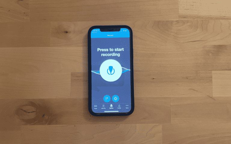
#1 Paddle Logger

When you embark on your paddle boarding adventures, Paddle Logger stands out as a must-have app.
Designed for both novices and seasoned paddlers, this app enhances the tracking of your paddling activities, whether that’s on a SUP, kayak, or canoe.
With safety at its forefront, Paddle Logger offers easy start and finish tracking of your watery journeys.
Below are some key features:
- Simple Tracking: Start a new session with a tap.
- Apple Watch Integration: Convenient control from your wrist.
- WaterLock Mode: Protection for your sessions on the water.
The app allows you to review past sessions, complete with metrics and maps to visually reminisce your paddling routes.
You can also easily:
- Share adventures with friends.
- Keep a logbook of your sessions.
- Utilize safety features like the Safety Session and the PaddleLIVE services, which keep designated contacts informed of your whereabouts.
Here is a quick rundown of the user interface elements:
| Element | Functionality |
|---|---|
| Track Button | Initiates recording |
| Map Screen | Displays your route |
| Session Log | Archives past adventures |
| Share Option | Connects to social platforms |
The app’s design, aimed at clarity and utility, comes from a paddle boarder’s perspective, making it highly user-oriented.
To better understand how Paddle Logger fits your paddle boarding experience, consider the app’s focus on utility for paddlers.
Whether you’re casually paddling in a local bay or training for a race, Paddle Logger seeks to be your digital companion on the water.
#2 Go Paddling
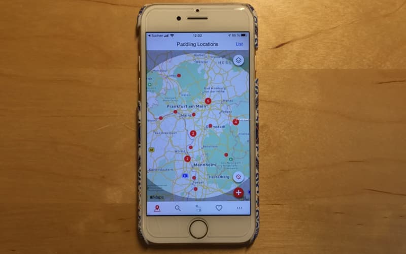
When you’re searching for that perfect place to launch your stand-up paddleboard, the Go Paddling app is your go-to resource.
This app proudly boasts an impressive database with over 25,000 paddling locations, ensuring you can find an ideal spot whether you’re close to home or on the road.
- Location Access: Simply input your current location to discover nearby paddle boarding sites.
- Launch Points: Go Paddling provides detailed information on launch points to ease your entry into the water.
- User Reviews: Benefit from the experiences of fellow paddlers through user-submitted reviews.
Ease of Use: Go Paddling stands out for its user-friendly interface.
With just a few taps, you can access a wealth of information on paddling destinations, which can be particularly useful for planning spontaneous trips.
Features:
- Map of local spots
- Information on parking & accessibility
- Details on water conditions
Community Contributions: You can contribute to the app by adding new locations or updating the status of existing ones, making it a collaborative platform. This feature of the Go Paddling app helps ensure that the database remains current and valuable for all users.
#3 Runtastic (Adidas Running)
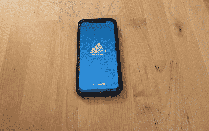
When you’re ready to complement your paddle boarding experience with fitness tracking, Runtastic (Adidas Running) is an app to consider.
Tailored for runners, it also offers valuable features that you can utilize during your water-based adventures.
- Activity Tracking: Record your paddle boarding sessions to monitor distance, duration, and calories burned. This will give you a clear insight into your progress over time.
- Personalized Goals: Set targets for each paddle session to keep your fitness journey on track. Whether it’s increasing distance or endurance, Runtastic helps you stay focused.
- Community Features: Connect with friends and other users. Sharing your successes or joining challenges can boost your motivation.
- Live Maps: The live maps function can be useful to explore new paddle boarding locations or track where you’ve been on the water.
Remember that Runtastic is primarily designed for running, so some features may be more suited to land-based fitness. However, the app’s tracking capabilities make it a versatile companion for a range of activities, paddle boarding included.
To get started with Runtastic on your paddle boarding adventures, download the app from the App Store or Google Play, and explore its functionalities that align with your needs on the water.
With real-time stats and a supportive community, enhance each paddle stroke towards a fitter you.
#4 iOverlander

iOverlander is a robust app that serves both the paddle boarding community and travelers at large.
Although not exclusively designed for paddle boarders, it offers essential features that can come in quite handy for your aquatic adventures.
With iOverlander, you can discover new paddling spots that users have shared, which may include local knowledge that you might not find elsewhere.
Key Features:
- Spot Discovery: Access a database of places, submitted by a community of users, perfect for finding new locations to paddle board.
- Trip Recording: While not its primary feature, iOverlander allows you to keep track of your paddling routes and tours.
- Community-Based Information: Learn from the experiences and tips shared by fellow paddlers and outdoor enthusiasts.
The app’s interface is user-friendly and is structured to facilitate easy navigation through its various functions.
It’s designed to help you plan your journey by providing information about potential stop sites and giving insights into various points of interest, including hazards to avoid.
Availability:
- iOverlander is available to download globally.
- It offers a blend of free features along with some paid options for those seeking additional functionality.
To conclude, if you’re someone who paddles in various locations and enjoys exploring, iOverlander can be a valuable tool in your arsenal.
Its community-driven nature makes it a unique resource for connecting with the broader paddle boarding community and discovering the ins and outs of new paddling destinations.
#5 Paddle Monster
When you’re seeking to enhance your paddle boarding experience with some coaching, Paddle Monster should be at the top of your download list.
This app is designed to connect you with top-tier paddling coaches, including Olympian Larry Cain and SUP champions like Travis Grant and Seychelle.
Key Features:
- Coaching: Get advice from world-class coaches.
- Community: Interact with a community of enthusiasts.
- Progress Tracking: Monitor your improvements over time.
Your progress in the sport can be tracked and analyzed, ensuring that you’re not just paddling aimlessly but are continuously improving.
Engaging with a community of like-minded individuals can keep you motivated and informed about the latest in paddle boarding.
How It Helps You Improve:
- Access to Expertise: Tailored coaching aids your technique development.
- Structured Training: Set goals and follow structured programs.
- Measure Performance: Easily track and analyze your performance metrics.
Whether you’re a beginner or an experienced paddler, Paddle Monster guides you through a variety of training regimes that can be tailored to your level, helping you reach your peak performance.
It’s clear that with this digital coach, you’re not just participating but actively improving in the sport.
#6 GeoSUP
When you’re ready to elevate your paddle boarding experience, GeoSUP is an app you should consider.
This application is fashioned specifically for stand-up paddle boarding enthusiasts, providing robust features to enhance your sessions on the water.
Features:
- Tracking Accuracy: Enjoy improved tracking accuracy for detailing your route.
- Stability Enhancements: Experience fewer interruptions with enhanced app stability.
- Spot Guide: Discover new paddle boarding spots with an integrated guide.
- User-Friendly Interface: Navigate through the app with ease.
- Price: The app is available for $4.99, a worthwhile investment for avid paddlers.
By using GeoSUP, you can meticulously record and analyze your paddle boarding adventures.
Whether it’s pacing, route precision, or highlighting favorite locations, this app supports your journey from start to finish.
Further information regarding updates and user reviews can be found directly on the App Store.
Make sure to check for compatibility with your iPhone to ensure the best possible experience.
GeoSUP stands out for its specialized attention to the sport, making it a fitting companion for both casual and serious paddle boarders.
#7 Watersports Tracker
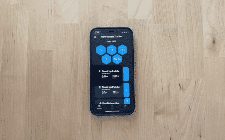
When you’re on the water looking to enhance your paddle boarding experience, the Watersports Tracker app becomes an indispensable tool for your adventures.
Designed to cater to various watersports activities, this app focuses on tracking your performance and offers a range of features to support your journey.
Key Features of Watersports Tracker:
- GPS Tracking:
- Tracks your route on the water
- Monitors speed and distance
- Performance Analysis:
- Provides detailed statistics about your paddling session
- Displays your progress over time
- Social Sharing:
- Allows you to share your routes and stats with friends
- Connects you with a community of paddlers
Further Practicalities:
- Available on both iOS and Android platforms
- Optimized battery usage to ensure longevity during use
To make your paddle boarding more informative and social, you can rely on Watersports Tracker’s tracking and sharing capabilities.
It’s a tool that supports your commitment to your sport, whether you’re aiming for a serene paddle at sunrise or challenging yourself with distance and speed.
#8 Waterspeed

If you’re aiming to maximize your paddle boarding experience, Waterspeed is your go-to app for tracking a wealth of details during your water-based activities.
Specifically designed for water sports enthusiasts, Waterspeed allows you to use your iPhone or Apple Watch to record and improve your sessions.
Features:
- Device Integration: Seamlessly connect with your iPhone or Apple Watch.
- Session Tracking: Capture speed, duration, distance, and heart rate.
- Data Analysis: Review your performance with detailed metrics.
- Improvement Tools: Utilize feedback to enhance your paddle boarding skills.
When you start a session with Waterspeed, you’ll notice its user-friendly interface makes it simple to view real-time data right on your wrist or phone.
The app not only tracks over 3 million paddling activities but also boasts high user satisfaction, reflected in its 4.8-star rating on the App Store.
With more than 20 million miles already tracked, you can trust it to accurately document your waterway adventures.
You also get the advantage of joining a community that has surpassed 400,000 downloads — a testament to Waterspeed’s popularity and reliability among paddle boarders.
Make every paddle count by leveraging the app’s comprehensive features to elevate your paddle boarding technique and safety.
To get started with Waterspeed and transform your device into the ultimate tracker, visit the Waterspeed website for more details and app download.
#9 Windalert
When paddle boarding, weather conditions are crucial for your safety and enjoyment.
WindAlert is a specialized app that gives you real-time wind reports and forecasts.
With this app at your fingertips, you can plan your SUP excursions with confidence, knowing you have up-to-date wind information.
- Real-Time Data: You get live wind speeds and directions from over 50,000 weather stations worldwide.
- Forecasts: Gain insights into future conditions with hourly and daily predictions.
- Map Interface: View wind data on an interactive map to easily understand how it affects various locations.
- Favorites: Save your most visited locations for quick access to the wind data that’s most important to you.
The WindAlert app also has customizable wind alerts, so you receive notifications when the wind conditions meet your preferred settings.
Whether you’re a beginner looking to avoid strong winds or an experienced paddler searching for the best breeze, WindAlert tailors to your needs.
To get started, download the app from your respective app store.
Once installed, you can personalize the settings to align with your paddle boarding preferences.
Use the graphical interface to visualise wind trends and make informed decisions before you set off on your SUP adventure.
Remember, conditions on the water can change rapidly, so keep WindAlert handy for updates throughout the day.
#10 Motionize SUP
Motionize SUP is a specialized app designed to enhance your stand-up paddleboarding experience.
This tool targets your performance analytics, aiming to give you valuable feedback on your paddling technique and progress.
Key Features of Motionize SUP:
- Performance Tracking: It captures essential data such as stroke rate, distance per stroke, and paddle depth.
- Real-Time Audio Feedback: This feature allows you to receive instant audio cues to improve your paddling form while still on the water.
- Video Analysis: You can record your sessions and analyze your form post-paddle.
| Attribute | Detail |
|---|---|
| Tracking Precision | High |
| Feedback Mechanism | Audio |
| Analytical Depth | Comprehensive stroke analysis |
| Usability | Intuitive interface |
To get started, simply download the Motionize SUP app on your smartphone, mount it onto your board, and the sensors will do the rest as you paddle. Remember, the more you understand about your technique, the more efficiently you can paddle, thereby enhancing your overall SUP experience.
#11 Windy
When planning your paddle boarding sessions, staying informed about the weather conditions is crucial. Windy is an exceptional app that equips you with detailed weather forecasts, focusing on wind, waves, and currents. With this app at your fingertips, you are capable of making well-informed decisions about when and where to paddle board.
- Accessible Data: Windy provides comprehensive data on:
- Wind speed and direction
- Wave heights
- Currents and tides
- User-Friendly Interface: The app’s clear and intuitive interface allows you to easily navigate and understand the meteorological data that matters to you most.
- Temperature and Visibility: Gain insights into not just the wind and waves, but also the temperature and visibility for the day.
By using Windy, you can anticipate the perfect time to head out onto the water, ensuring your safety and maximizing the enjoyment of your paddle boarding experience. The app’s up-to-date information helps you to avoid any unforeseen weather changes that could affect your outing.
Remember, always check the conditions before you set off to ensure a safe and pleasurable paddle boarding adventure. With Windy, you’re equipping yourself with a powerful tool for any water-bound excursion. For more detailed information and to plan out the best paddle boarding experience, consider Windy as your go-to wind app.
#12 RiverApp
When you’re gearing up for your next paddle boarding adventure, safety and preparedness are crucial. RiverApp, specifically tailored to meet the needs of paddle boarders like you, is an essential tool to add to your digital toolkit. Before setting out, you can check real-time water levels and river conditions to ensure your chosen spot is safe and navigable.
Here are the features you can expect from RiverApp:
- Real-time Data: Get up-to-date information on over 20,000 sites in North America and Europe.
- Water Conditions: Know about currents, flow rates, and water temperature to plan your trip effectively.
- Safety Alerts: Stay informed about potential hazards or changes in conditions.
- Community Insights: Benefit from the shared knowledge of other paddlers’ experiences.
To make the most out of RiverApp, follow these simple steps:
- Download: Get the app on your smartphone; it’s designed for both iOS and Android users.
- Set-Up: Customize your settings to receive alerts and information relevant to your favorite paddling locations.
- Explore: Use the app to discover new waterways and track conditions on the go.
RiverApp serves as a reliable companion that keeps you informed and ready for the water, ensuring your experience is not just enjoyable, but also secure. Stay updated with RiverApp and paddle with confidence, knowing you have the latest information right at your fingertips.

FAQ
What are the top-rated applications for tracking paddle boarding activities?
For tracking your paddle boarding activities, apps like Go Paddling and Paddle Logger are highly rated for their user-friendly interfaces and robust tracking features.
Which mobile apps for paddle boarding offer the best features for route planning?
When it comes to route planning, Watersports Tracker is a great choice, offering detailed mapping tools to help you plot your next journey on the water.
Can I monitor my paddle boarding workouts using a fitness tracker app?
Yes, you can use fitness tracker apps like Runtastic to monitor your paddle boarding workouts, which will track your progress and provide valuable metrics like distance and calories burned.
Are there any specialized paddle boarding apps compatible with the Apple Watch?
Specialized paddle boarding apps such as Waterspeed offer compatibility with the Apple Watch, allowing you to keep track of your activities and vital stats directly from your wrist.
How do I find popular paddling locations using paddle board mobile applications?
Mobile applications like Maps.me can help you discover popular paddling spots with their extensive directory and user-contributed data on locations around the world.
Is there a way to simulate or practice paddle boarding techniques using an app when off the water?
Currently, there are limited options for simulating paddle boarding techniques through an app. However, some apps may offer instructional videos and tips that can be useful for practice when you’re not on the water.


